Castles in the Sand
H. Crane Miller
This article originally appeared in Southern Exposure Vol. 10 No. 3, "Coastal Affair." Find more from that issue here.
At first the brochures came from quite nearby, from Delaware and Maryland. Then they arrived from further down the South Atlantic and even the Gulf Coast. Our nation’s coastal islands are developing swiftly, and the markets extend well beyond my home in Washington, DC.
These islands are a succession of narrow, low-lying barriers, spits, tombolos and cuspate forelands running generally parallel to the mainland coast. They reach from Maine to Mexico, but 97 percent of their undeveloped acreage is in the South. In the last few years, they have become the subject of a lively debate between developmental and protectionist interests. In the midst of this debate, though, the very substantial costs of developing these islands — costs borne by both buyers and the general public — are seldom discussed.
Meanwhile, the brochures arrive more frequently. The offerings look attractive: the high dunes and wind-blown sands of North Carolina’s Outer Banks, the semi-tropical quality of the Sea Islands, the sun setting over Georgia’s marshes of Glynn, sea oats bending before the wind and beach grass etching fragile designs in the white sands along Florida’s shores, and many other glossy color visions that recall memorable summer days. Couple these alluring images with the increased leisure time and surplus income of upper-income Americans, and you arrive at the formula the Kiawah Beach Company, among others, put its finger on in 1974 when rationalizing the resort development of one South Carolina island: “This fundamental urge to vacation, or preferably live near the ocean, has led to the dramatic increase in new, ocean-related communities along the South Atlantic Coast. Swimming, fishing, sailing, sunbathing, beachcombing and other water-based activities are the most important recreation activities for most Americans according to the Bureau of Outdoor Recreation.”
The brochures I receive tell me, or the current occupant at my address, that I am a definite winner — one of the fortunate ones able to acquire oceanfront property and “slip away from the mainstream bustle into the tranquility of Nature.” Permit me at least to wonder, if not doubt, how tranquil life would be on the islands. For the last 20 years, significant stretches of the Southern shore have enjoyed an unusual respite from major storms, creating a false sense of security among the millions of newcomers to coastal communities.
“The 60,000 people who live in the Florida Keys feel they don’t have a bad storm problem,” wrote the authors of The Beaches Are Moving in 1979. “What [they] don’t know may one day kill thousands of them.” [Wallace Kaufman and Orrin Pilkey, The Beaches Are Moving (Doubleday, 1979), p. 133.] Historically, Florida has averaged one hurricane every 1.6 years; but for Hurricane Eloise, however, it has escaped real devastation since the 1950s. The National Hurricane Center in Miami tells us that, because of the recent mass migration to coastal areas, 80 percent of those living in the “hurricane belt” have never experienced a major storm.
But what about the next 20 or 30 years, the life span of a typical mortgage? In that time, the mathematical probabilities give my house on a Southern barrier island an 18 to 26 percent chance of being struck by a devastating 100-year storm, and a 33 to 45 percent chance of a less violent, but still destructive, 50-year storm.
Building near the ocean is a gamble with time and nature. And despite the picture some would paint of innocent lambs being led to slaughter, many people who own property on the shores are well aware of the hazards. “I know what happened before, but this is where I want to be” was the oft-repeated sentiment of homeowners on a Rhode Island beach swept clean of all structures by hurricanes in 1938 and again in 1954. For them, building near the ocean is a gambol with time and nature. [Note: People who live in coastal and riverine flood-prone areas were surveyed in the mid-1970s to determine their attitudes toward flood losses and rebuilding after floods; see: H. Crane Miller, Coastal Flood Hazards and the National Flood Insurance Program (Office of Federal Insurance Administration, Department of Housing and Urban Development, 1977).]
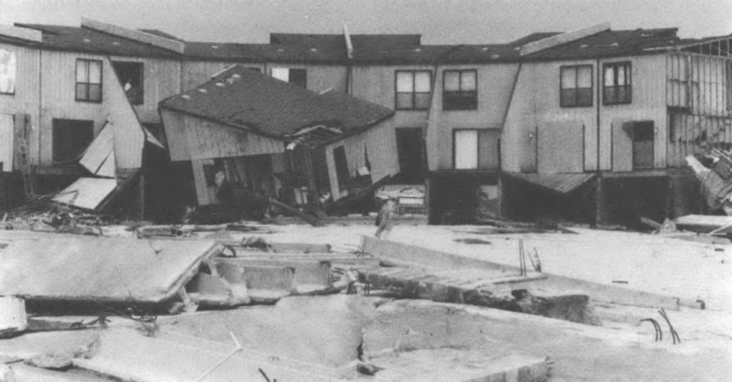
In the aftermath of Hurricane Frederic, Alabama coastal residents steadfastly refused to back away from the water’s edge. Frederic struck the coast at Dauphin Island about midnight on September 13, 1979. From there east for some 30 miles, the storm cut an awesome swath of destruction and caused about $2 billion in damages along the coast and inland. Fort Morgan, at the mouth of Mobile Bay, felt the greatest winds, about 120 miles per hour with gusts much higher. Wind-driven water at least six feet deep swept across much of the peninsula near the fort, leveling dunes and totally destroying 94 percent of the seaward-most homes for eight miles. Further east toward the town of Gulf Shores, the wind forces diminished but still destroyed more than two-thirds of the oceanfront homes.
Like all major storms, Frederic produced its tales of human tragedy — the man who refused to leave his home near Fort Morgan and was swept away; the couple who invested their life savings in a store on the water in Gulf Shores, only to have it demolished two weeks later by the hurricane (they had no insurance).
Two days after the storm, at a subdivision near Fort Morgan, we met a man who had a few dishes and bottles of soda in the back of his car. “That’s all that’s left of a $20,000 investment,” he told us.
“Do you have flood insurance?”
“No. But I guess I can take some of the loss off my taxes for the next few years.”
“Will you rebuild?”
“Expect so,” he replied.
As we surveyed the beach, we heard the story again and again. People were stunned by the magnitude of their losses, yet found some sense of community in their shared misery. With federal and state aid, they were determined to rebuild.
One year later, we returned to the area and found over 300 new houses built on the same sites as before. Condominiums were sprouting up as well. The road and water systems had been restored to their former condition, or were perhaps improved, and a building boom was underway. But some of the new construction is cause for real concern, because the building standards and practices often not only repeat the pre-storm conditions but also add new height not offset by greater depth and bracing in the piling foundations; thus they may be more likely to topple in a hurricane than the pre-storm houses.
FEDERAL POLICY ENCOURAGES DEVELOPMENT
The intense demand to build and rebuild on barrier islands strongly colors the background against which government policy decisions about their future development or protection are made. Despite education regarding the hazards, despite direct experience with major storms, development continues virtually unabated.
If storms are causing death and destruction, how has the federal government responded? A brief examination of federal strategies for flood loss management is instructive. The nineteenth-century approach was laissez faire: property owners who built on flood plains bore their own flood losses. About 1910, the government began authorizing various flood control projects, notably on the lower Mississippi River. Since the Flood Control Act of 1936, the federal government assumed national responsibility for flood control projects and has invested upwards of $11 billion on structural projects to reduce riverine and coastal flooding and related damages. Despite that investment, flood losses continue to rise: the U.S. Water Resources Council estimates that average annual urban flood losses now exceed $1.5 billion. A third strategy is evolving, marked in part by Congress’s attempt to shift some of the costs back to those who create the risks, the occupants of the flood plains and coastal hazard areas. It is also marked by a shift away from sole reliance on structural flood control works to methods such as flood insurance coupled with minimum building standards, and warning and evacuation programs. The National Flood Insurance Act of 1968 is Congress’s principal tool for this third strategy.
The national flood insurance program has grown so much that it is now the second largest commitment against the U.S. Treasury, topped only by Social Security. Of $98 billion in total flood insurance coverage, some $10 to $15 billion is for properties on the coastal barriers. The program has its critics, and their attack focuses mainly on its coastal coverage. They question whether the federal program does not, in fact, offer incentive and subsidy for building in hazardous areas. This is now the subject of great debate. (See box.)
In 1981, Congress prohibited federal flood insurance coverage for any new construction or substantial improvements to structures on undeveloped portions of coastal barriers after October 1, 1983. Negotiations are now underway to determine where this “undeveloped” acreage lies. Needless to say, developers are lobbying hard to keep their islands off this list.
Flood insurance is not the only way the federal government participates in coastal development. Since World War II, federal programs have shifted to the public a sizable share of the costs for island bridges, roads, causeways, water supply systems, wastewater treatment plants and erosion control, as well as disaster relief and
flood insurance. If current federal policies and expenditures continue unchanged, the cost to taxpayers of developing the remaining undeveloped islands could be more than five times what it would take to purchase them outright.
The rate of development is high: an average of more than 6,000 acres a year over the last 30 years. At that pace, the developable portions of the barriers will be consumed by 1995. According to an April, 1981, Interior Department inventory, about 460,000 acres remain neither developed nor protected. Texas and Louisiana account for two-thirds of all this acreage; North Carolina, South Carolina, Georgia and Florida each have more than all of the Northeastern states combined. And much of this land is ripe for more beachfront construction.
To understand the way development occurred, several colleagues and I studied nine communities on Southern coastal barriers in 1980 and found many common characteristics.* Typically, development began under the leadership of a local official or private developer. A bridge or causeway was the first necessity. Then the island needed a fresh water supply; though most islands lay atop shallow fresh water aquifers, these tended to become polluted as population densities increased. Wastewater could at first be handled by individual septic systems, but with further development, pollution necessitated a wastewater treatment facility as well.
In each community we studied, the initial development was financed by private capital, state or local revenue bonds or some other nonfederal source. But federal funding did come later, in successive rounds of expansion, upgrading, replacement and reconstruction of public infrastructures. When we tallied the actual federal expenditures and obligations for public infrastructures in the nine communities, they amounted to an average subsidy of $25,570 per developed acre. When restated in 1980 replacement costs, they averaged $53,250 per developed acre. In short, current federal programs encourage development of the coastal barriers at the public’s expense. We could continue on that course unchanged — and the forces to do so are substantial — but it would cost a great deal. My colleagues and I estimate that continuing on this course would cost the federal government from $5.5 billion to $11 billion over the next 20 years if the remaining coastal barriers were developed.
WHAT SHOULD FEDERAL POLICY BE?
It seems clear that the federal assistance cycle for coastal barriers must be broken. Available means include federal regulation, removal of subsidies and public acquisition of some of the barriers. Whichever strategy is employed, timing is critical: either we prevent development before it occurs, or we “correct” the damage after development. The further development progresses before protective actions occur, the less effective they can be and the more they will cost the public. (See article on Florida’s beaches, page 24.)
Because of the crucial role that bridges and causeways play in development, we could consider denial of bridge permits or the imposition of stringent (and costly) regulations on bridge building, with no option of federal rebuilding. Outright denial of bridge permits may be politically unattainable, but the second tool would add multi-million-dollar costs to island developments needing bridges.
Other kinds of federal and state regulations are also possible, though they generally will not prevent development over the long term. Some examples include stringent property elevation requirements, construction setback lines, and development moratoria where health, safety or other standards cannot be met. Standards like these help reduce losses, but they cannot prevent disaster.
Continued development, even with stringent minimum standards, increases the chance for catastrophic losses in the large, rare storm that eventually comes along. Continued development also presupposes major investments in roads, water systems and other community infrastructures, and serious damage to these can be expected from storms considerably less intense than the rare ones; federal flood insurance building standards don’t apply to these. Once all the infrastructure is in place, providing disaster relief after a storm is politically irresistible. Thus the cycle of building, disaster and rebuilding continues. Even the Coastal Barrier Resources System bills pending in Congress, which would curtail federal subsidies in ordinary circumstances (see box), leave the government open to funding emergency assistance and certain restorative work after disasters.
PUBLIC ACQUISITION OF THE ISLANDS?
Public acquisition of the still-undeveloped barrier islands is the surest yet most controversial way we have to protect them. Though frequently denounced as being too expensive, costs of acquisition compare favorably with other alternatives. We estimate that buying all the remaining barrier acreage would cost about one-fifth of the federal share of development under current programs.** Public acquisition is also the surest way to protect natural values and remove particularly dynamic areas from the recurring cycle of disaster relief, flood insurance and other federal expenditures.
Given the current political and economic climate, federal acquisition of all undeveloped island acreage is out of the question. But it might not be necessary to acquire islands that have no bridges. In fact, with stringent bridge construction standards and denial of federal subsidies, private interests would be hard-pressed to finance development on 50 or more of the remaining pristine islands. Under a public acquisition program, priorities would be set, and places that are most endangered could be bought up first.
We estimate that purchase of all of the land in the proposed Coastal Barrier Resources System would cost between $1 and $2 billion, roughly $5,000 to $10,000 an acre. Some 40 to 45 percent of this might be avoided if the federal government used the bridge regulation method in the areas mentioned above. If so, we as a nation could preserve the highest-priority undeveloped islands at a cost of $600 million to $1.1 billion and prevent, at the same time, spending perhaps five times those amounts if current subsidies continued unchanged. Even if pending legislation is approved, I estimate that the cost of federal subsidies could still be two or three times that of public acquisition.
On this subject, the issue is not legislative authority; ample authority for public acquisition is already on the books. The issue is one of political will, funding and differing concepts of what constitutes appropriate stewardship of the undeveloped barrier islands. The issue is critical: the coastal barriers of the South are developing, and the costly cycle gets harder to break with each passing year.
*Barrier Island Development Near Four National Seashores, a report prepared for and funded by the Council on Environmental Quality, Federal Insurance Administration, U.S. Fish and Wildlife Service, National Park Service, National Oceanic and Atmospheric Administration, and Office of Coastal Zone Management (Washington, 1981). A summary was published as “The Barrier Islands: A Gamble With Time and Nature,” in Environment (November, 1981). The communities studied were: Nags Head and Kill Devil Hills, North Carolina; Camden and Glynn Counties, St. Mary’s, St. Simon’s and Sea Islands, Georgia; Pensacola Beach, Florida; Dauphin Island, Alabama; and South Padre Island and Cameron County, Texas.
**The estimates were prepared for testimony on coastal barriers legislation pending before Congress: John R. Sheaffer and Louis Rozalkis, testimony before the House Committee on Interior and Insular Affairs, on H.R. 5981, March 27, 1980; John R. Sheaffer, H. Crane Miller and Louis Rozalkis, statement before the Senate Committee on Energy and Natural Resources on S. 2686, June 12, 1980; H. Crane Miller, statement before the Senate Subcommittee on Fisheries, Wildlife Conservation and the Environment, Committee on Merchant Marine and Fisheries, on H.R. 3252, June 23, 1981.
For further reading on shoreline ecology and developmental follies, The Beaches Are Moving by Orrin H. Pilkey, Jr., and Wallace Kaufman is a creatively informative account of “a vision of how we can live with and love our beaches without destroying them or ourselves.” Published by Anchor Press/Doubleday in 1979, the book is no longer available in stores but may be ordered for $5 pre-paid from Dr. Orrin H. Pilkey, Jr., Dept, of Geology, Duke University, Durham, NC 27708.
Tags
H. Crane Miller
H. Crane Miller practices law in Washington, DC. He has been general counsel of Sheaffer & Roland, Inc.; counsel on oceans and atmosphere to the Senate Commerce Committee; and assistant general counsel to the Smithsonian Institution. (1982)