Graphic anatomy of a toxic radioactive waste plume
The U.S. Department of Energy published a public notice in local newspapers today to "inform the public of DOE enforceable requirements for protection of human health and the environment from past releases of contaminants within the Melton Valley portion of the Oak Ridge Reservation located in Roane County, Tennessee."
According to the notice, the "predominant contaminants of concern that could potentially cause a threat" are:
• in soil: cesium-137, strontium-90, cobalt-60, curium-244
• in surface water: tritium, strontium-90
• in sediment: cesium-137, strontium-90, cobalt-60, curium-244, PCBs
• in groundwater: tritium, strontium-90

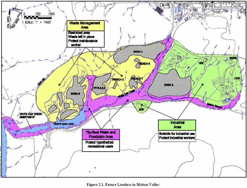
A map similar to the one above (click for a larger view) was included in the public notice. It is a graphic illustration of how a toxic, radioactive plume spread from ORNL operating and waste storage/dumping sites to contaminate one of the most toxic EPA Supersites in the country.
(The above map was submitted to the DOE by a site specific cleanup committee as part of a recommendation on what should be included in the public notice. The recommendation was made in Dec. of 2006 after months of study and meetings. The DOE responded in March of 2007 that they generally agreed, and the notice was finally published in Dec. 2007 with some changes.)
The area at the top right of the map is the Oak Ridge National Laboratory. The general area of the map is the Melton Valley and the White Oak Creek embayment, which empties in to the Clinch River on the lower left and eventually into the Watts Bar reservoir on the Tennessee River.
The area marked in yellow is designated as a "Waste Management Area" (renamed "Waste Disposal Areas" in the DOE public notice), where radioactive and other toxic waste is left in place. These areas are restricted from any use other than waste disposal and the land use plan requires protection of maintenance workers entering the area. It's not clear from the map included in the public notice, but it appears this area was reduced in size to only include the actual waste disposal areas, which are indicated on the above map in gray.
The areas marked in green are designated as "Industrial Use Areas" that are "suitable for industrial use" with restrictions that prohibit excavation and ground penetration of more than two feet.
The area marked in purple is designated as a "Surface Water and Floodplain Area", with restrictions to protect "hypothetical recreational users."
Restrictions in all areas prohibit access or use of groundwater.
The public notice advises that "Because land use on Melton Valley is restricted due to the continuing presence of hazardous substances at levels that do not allow for unrestricted use, the Record of Decision [ed. note: Melton Valley Land Use Controls Implementation Plan ROD DOE/OR/01-1977&D6], requires production of Notations on Ownership Record (Deed Restrictions) and Property Record Notices to define the restricted areas." The ROD lays out requirements for the DOE to report to the Roane County Register of Deeds all boundaries and restrictions, and includes other controls such as signs, surveillance patrols, and permit programs.
The overall area is designated as an EPA Superfund site and cleanup work has been ongoing for decades. EPA information on the site is here.
Reading the long list of cleanup work, or in some cases sites simply abandoned as being too toxic to clean up, is scary. It's a reminder that, fifty years ago, our top nuclear scientists and engineers thought their toxic radioactive waste storage and disposal plans were safe and sound. What will America be saying thirty, forty, or fifty years from now about nuclear waste disposal decisions being made today, which are making "disposal" and "cleanup" largely a shell game?