IMPACT: Mass of Gulf oil spill poised to strike coast over next 72 hours
While bits and pieces of the Gulf oil spill have already reached shore, new federal maps show that the larger floating mass of oil generated by the disaster is poised to strike the coast over the next three days.
Each day, the National Oceanic and Atmospheric Administration (NOAA) releases maps on the projected course of the oil spill. In their report for Thursday, May 13, NOAA's scientists predict that in the next 24 hours, the periphery of the oil mass will begin reaching the outer reaches of Louisiana's coast for the first time, touching the coastal marshes near Venice.
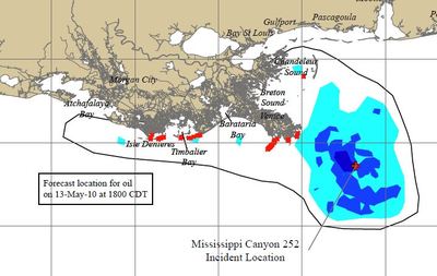
Heading into the weekend, NOAA's projections show the mass of the spill continuing to move closer, with heavier concentrations of oil reaching the shoreline. Here's NOAA's 72-hour projection:
As the oil mass comes to shore, the environmental and economic impact of the disaster will become clearer. Spilled oil will be the latest trauma to inflict Louisiana's rapidly disappearing coastal wetlands, which are key to the fishing industry, ecologically rich and one of the best defenses against Gulf hurricanes.
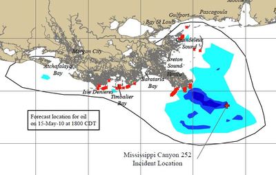
Each day, the National Oceanic and Atmospheric Administration (NOAA) releases maps on the projected course of the oil spill. In their report for Thursday, May 13, NOAA's scientists predict that in the next 24 hours, the periphery of the oil mass will begin reaching the outer reaches of Louisiana's coast for the first time, touching the coastal marshes near Venice.

Heading into the weekend, NOAA's projections show the mass of the spill continuing to move closer, with heavier concentrations of oil reaching the shoreline. Here's NOAA's 72-hour projection:

As the oil mass comes to shore, the environmental and economic impact of the disaster will become clearer. Spilled oil will be the latest trauma to inflict Louisiana's rapidly disappearing coastal wetlands, which are key to the fishing industry, ecologically rich and one of the best defenses against Gulf hurricanes.
Tags

Chris Kromm
Chris Kromm is executive director of the Institute for Southern Studies and publisher of the Institute's online magazine, Facing South.