CHRONIC EXPOSURE
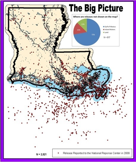
Map of oil spills in Louisiana in 2009 by the Louisiana Bucket Brigade.
Along the Gulf Coast, the oil industry's harm to communities' health goes far beyond the BP disaster.
A special Facing South investigation by Sue Sturgis
In the offices of the Louisiana Bucket Brigade, a grassroots nonprofit in Mid-City New Orleans, a large map of the state and the Gulf of Mexico hangs on one wall. The map is covered with thousands of red dots — some on land, some on the water, and most clustered where the Louisiana coast and Gulf of Mexico meet.
Each dot represents an oil spill that happened in 2009, the year before the BP disaster.
There are 3,600 in all.
The map (at right; for more details and an explanation of the data click here), created in partnership with environmental planning students at the University of New Orleans, was one of the first attempts to visualize Gulf oil spill pollution using data from the National Response Center, the federal agency that collects reports of oil, chemical and radiological spills in the United States.
The results were striking: While the scope and scale of the 2010 BP calamity was certainly beyond anything the Gulf had experienced before, toxic oil spills have been a routine byproduct of region's energy economy.
"There's a history of chronic chemical exposures in this state," Mariko Toyoji, a research analyst who helped compile the report, told Facing South.
They found that some of the spills have been going on continuously since Hurricane Katrina struck the Gulf Coast in 2005. 315 of the spills occurred within a mile of a public school. Many of the spills involving pipelines happened along coastal wetlands, an environmentally sensitive area critical to the fishing industry.
Spills haven't been the only way Louisiana's oil has been finding its way into communities and ecosystems. The Bucket Brigade also compiled a database of accidents at oil refineries between 2005 through 2010. Drawing on reports submitted by companies, the group found there were 2,849 reported accidents at the state's 17 refineries, an average of about two a week.
The result of these refinery mishaps: A total of 22 million pounds of pollution was released into the environment, including highly toxic and cancer-causing chemicals such as benzene and volatile organic compounds.
"The BP oil spill is a great illustration of the dynamics happening every day in this state," says Anne Rolfes, the Bucket Brigade's executive director. "These accidents are happening all the time, and there's no enforcement." 'What you don't know can hurt you'
Today, Louisiana is the fourth-biggest oil-producing state in the U.S. after Alaska, Texas and California. The birth of the industry in Louisiana can be traced back to 1901, when the Heywood well in Jefferson Davis Parish in southwestern Louisiana began producing the first oil in commercial quantities. Eight years later a refinery opened in Baton Rouge; today ExxonMobil's Baton Rouge refinery is one of the largest in North America.
While the oil industry undoubtedly brings benefits to many in Louisiana, with one study estimating its total direct and indirect economic impact at $65 billion a year, those benefits are not distributed equitably — and neither are the drawbacks. As scholar Barbara L. Allen details in her book Uneasy Alchemy: Citizens and Experts in Louisiana's Chemical Corridor Disputes, after the Civil War the federal government distributed farmland to the newly freed slaves, often on or near the plantations where they had previously worked, and typically deeded the land to extended family groups. When the oil refineries came later, they bought the larger plantations from wealthy whites, thus avoiding the need to negotiate with multiple owners whose title to the land wasn't always clear.
"The oil industry replaced the plantation economy after Reconstruction," observes Monique Harden, an attorney with Advocates for Environmental Human Rights in New Orleans.
This explains why many oil refineries and other petrochemical facilities were built next to African-American communities, which then bore the brunt of the pollution. These facilities were concentrated along the Mississippi River, which in addition to supplying a key shipping lane also served as a convenient place to dispose of the industry's toxic wastes. The 85-mile stretch of river from Baton Rouge to New Orleans eventually came to be known as "Cancer Alley" by local leaders and environmental health advocates because of the concentrated illnesses experienced by residents near the polluting industries.
One of these towns is Norco, located in St. Charles Parish about 25 miles west of New Orleans. Today Norco is home to 3,500 people and six major oil refineries and petrochemical plants. In 2009, these facilities reported releasing more than 1.1 million pounds of toxic pollution to the air.
Iris Carter (photo above), who was born in segregated Norco's African-American neighborhood of Diamond in the early 1950s, remembers when the Shell Chemical plant expanded to the edge of her community. She grew up smelling terrible odors, and watching the indignity of the plant's good jobs going to whites who lived farther away.
A turning point came in 1973, when the mere spark from a resident starting a lawnmower above one of the plant's leaking underground pipelines was enough to trigger a blast that killed two people. Diamond's residents decided they'd had enough, and began picketing the facility and demanding that Shell relocate them.
"When Miss Helen and that boy blew up [from the explosion], that was the deciding thing," Carter said in an interview with Facing South.
After pressure from Carter and the Concerned Citizens of Norco, Shell finally agreed to buy out Diamond residents, who had grown so rattled by the plant's frequent accidents that they took to sleeping fully clothed in case they had to flee in the night. Of about 200 families that once called the community home, only about 20 remain today, their houses scattered among open fields.
Years of toxic exposures have taken a toll: Carter has been diagnosed with environmentally related asthma, and her daughter is also an asthmatic. Carter's mother died of cancer, and one of her sisters died of the autoimmune disease scleroderma -- two illnesses Carter says are common in Diamond. Another sister is currently being treated for a rare blood cancer.
"We didn't know it was dangerous," Carter says. "Sometimes what you don't know can hurt you." A 'come-to-Jesus' moment?
Norco's experience is far from exceptional: The energy companies lining the Mississippi River routinely unleash enormous amounts of pollution, which eventually empties into the Gulf of Mexico.
Facing South analyzed data from the Environmental Protection Agency's Toxics Release Inventory, which compiles pollution data self-reported by industry. We looked at the 19 petroleum industry facilities in EPA's database that are located in the Louisiana parishes along the Mississippi River for the five-year period from 2005 through 2009.
During that time, those 19 facilities dumped a total of more than 24 million pounds of toxic chemicals directly to the river or to other nearby waterways that drain into the Mississippi.
On top of that, they emitted another 237 million pounds of toxic chemicals to the air, some of which eventually end up in the river following rains that wash them from the air and land. This map shows the location of the facilities; click on the red dots for more details about their specific releases measured in pounds.
Much of this pollution ends up in the Gulf of Mexico, which in addition to oil spills and refinery effluents faces another threat: the Gulf Dead Zone.
Scientists believe the Gulf Dead Zone is caused by a mix of high-nitrogen fertilizer from Midwestern farmland and sewage run-off, which has caused an explosion of algae that robs ocean waters of oxygen, making it unable to support other aquatic life. Last year's Gulf Dead Zone was one of the largest ever measured at over 7,700 square miles — almost the same size as New Jersey.
The BP disaster seems to have exacerbated these ongoing threats to the health of the Gulf.
Since the spill, fishermen have been reporting unusual problems with their catches: lesions on shrimp, crabs with holes in their shells, red snapper with rotting fins. Meanwhile, dead dolphins have been washing up on Gulf beaches in unprecedented numbers, leading the federal government to declare an "unusual mortality event."
BP announced that August that it would fund a three-year state study of the oil spill's impact on Gulf fisheries. However, it hasn't agreed to fund the longer-term and more comprehensive fisheries study that Louisiana Gov. Bobby Jindal requested.
And there appears to be little interest in studying the impact of oil pollution — BP's and beyond — on the Gulf's people and communities.
While the National Institutes of Health announced last September that it was launching a multi-year study to look at the disaster's health impact on 55,000 cleanup workers, many of whom are now reporting illnesses they believe are related to the spill, there is no comparable effort to study the health of Gulf residents who weren't part of the cleanup. And there are no programs to provide health care or medical assistance to those who may be affected by toxic exposures from the disaster.
In the meantime, the ongoing threats posed by the Gulf's energy companies continue. Just last month, another oil spill of mysterious origins that was eventually blamed on an Anglo-Suisse Offshore Partners well damaged by Hurricane Katrina in 2005 dumped another estimated 640,000 gallons of oil into the Gulf.
"A reckoning with the oil industry needs to happen," says Anne Rolfes. "We need a come-to-Jesus moment."
Sue Sturgis is an investigative reporter and editorial director of Facing South. This is the third installment in an in-depth, week-long series by Sturgis and Facing South Publisher Chris Kromm on the growing health crisis in the Gulf in the wake of the BP disaster and the government's failure to respond adequately. To read the previous installments, click here and here.
PHOTOS: Map of oil spills by the Louisiana Bucket Brigade; Iris Carter by Sue Sturgis, Institute for Southern Studies; Gulf Dead Zone by the National Oceanic and Atmospheric Administration; Google map of oil facility toxic releases by the Institute for Southern Studies using the Environmental Protection Agency's Toxics Release Inventory data.
Tags

Sue Sturgis
Sue is the former editorial director of Facing South and the Institute for Southern Studies.